
Le Rozier sits at the confluence of the Tarn and Jonte rivers. My plan was to exit this area by riding east through the Jonte river gorge. To visualize the area, these two rivers form a kind of "C" with the Tarn being the top and side and the Jonte the lower part.
I also knew that there would be a lot of climbing later in the day as I climbed out of the gorge, crested the hills, and went down the other side. There would be two 1000 meter passes that I have to get up and over. While there weren't many roads that go through this area, it appeared from my map that I had a choice of two. I'd gotten conflicting advice on which one to take and wanted to wait until I got closer to the decision to see what the local TI had to say.
I was up early and walked down to the store for some "fresh" bread. His produce section was unchanged from the day before and I bought some yogurt for breakfast. I came back and was packed and out by 9am.
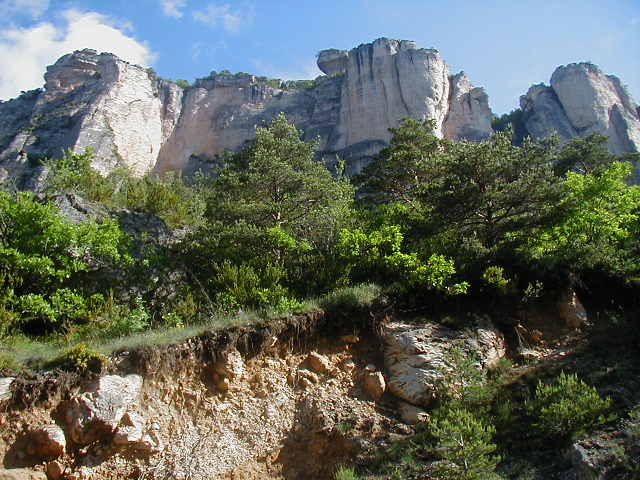
The road to the Gorges du Jonte was easy to find as I merely had to keep riding down le Rozier's main street. A few miles out of town yielded this view.
As you can see, it was an over-bright sunny day with fog in the distance. For the first time in days I put on some sun screen.
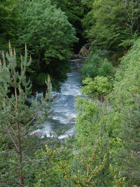
I was going downstream on the Tarn but on the Jonte, I was headed up.

This view reminded me of Yosemite.

At this part of the valley, I was fairly close to the river.

The scenery was a continuation of the Tarn gorge with rock outcroppings, lush growth, and villages in the distance.


The steady climbing took me further and further above the river.

Around one turn, the entire valley was laid out in front of me.

My map didn't show any villages in this valley but I saw this pretty one and had to take a photo.

The Jonte was smaller and seemed to run faster than the Tarn.
Yet again, the hillside mosaic of green and white was stunning.

I think it was the blue flowers that called out to me in this patch.

The 12 miles along the gorge went quick and I was soon in Meyrueis. I have no idea how to pronouce this town's name. I found that every time a French word had more than 2 vowels in a row I would say it wrong. This one has 4!
Meyrueis is a good-sized town and I stopped in a supermarket on the outskirts of town but their produce wasn't all that attractive. I bought a few snacks.
The Jonte goes through Meyrueis and the old part of town is layed out along it.

I sat in the, now hot, sun and ate a sandwich. It was so nice, I bougth an ice cream for desert. I went into the TI and talked with the agent for a while about my upcoming route. There were two roads that I could take. One was called the Corniche des Cevennes and would require the most climbing. The other one appeared to go along the side of the hills, along the le Gardon de St-Jean river. That was the one I was interested in. Unfortunately, the TI guy said that he believed the second one was closed due to road construction and that I'd have to take the Corniche road. He said it would be a lot of climbing but was a nice road, nonetheless. I figured I would decide when I got to the turn off, which was still about 15 miles away.
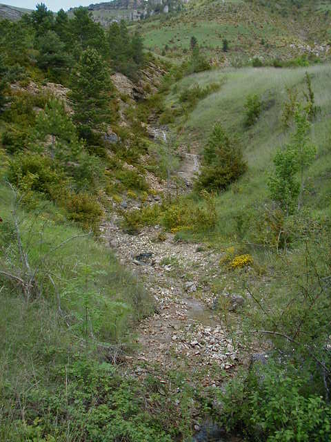
The road out of Meyrueis started up immediately. I was riding up the side of a valley.

As the road rose, it began hugging the hills.

I heard the gurgling of this creek as I rounded a corner.
After all this time, the views through the valley still made me gasp.

As I climbed higher, the weather got worse. The wind picked up and it started to rain. I could see that I still had a ways to go to the top.

It was a tough, wet grind up to the top. There were no shelters of any kind next to the road and not many large trees. Once or twice, I stopped under a tree to avoid some of the heavier rain but for the most part, I just kept pushing the pedals and slowing gaining altitude.
At one hairpin, I passed this cascade.

The weather at the top was so bad, I didn't stop for a photo or to denote it in any way. I still felt OK and just want to get through the coming wet downhill safely.
The downhill run was fairly short and about halfway down the rain stopped. By the time I hit the bottom, the sun was out again. I hit the cut-off junction and didn't see any indication that the road was closed for construction. But, the uncertainty of climbing up for several miles only to be turned around, caused me to go on.
I rode along the Tarnon river for a few miles. The town of Vebron is in the distance.
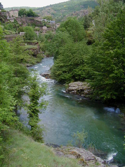
Here is another picture of the Tarnon a bit further downstream.

The town of Vebron. Note the blue sky.

A bridge crossing the Tarnon at the town of Vebron.

I was filling good enough to give a jaunty wave to some men I passed who were sitting on the side of the road. I'd crested one 1000 meter pass, was still feeling pretty good, and the sun was out. My last view of the Tarnon.

Then, I turned off and saw this sign.
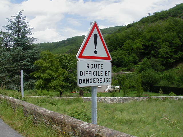
I didn't know it at the time, but the sign isn't kidding.
This road was a "shortcut" over to the Corniche des Cevannes that saved me 10 miles. But, it was a killer. It was full of steep switchbacks that forced me into my lowest gear. I was out of breath at the end of each switchback and would rest for a few minutes at each one. I kept hoping the next one would be the last, but I just kept climbing and climbing. It was,as the sign said, "difficile."
But, the last switchback did eventually arrive and as I went over the brow of a hill, the road straighten and flattened. But, I knew from the map that I wasn't at the top. The road curved to the left and started up again, in earnest. Only this time, the rain started, again.
I struggled uphill, completely soaked. There were no trees or shelters to get under. I could stop and get rained on or keep riding and get rained on. I recall thinking that I knew there would be moments like this. But, that didn't make it any more enjoyable!
It was more up and more rain. After about an hour of hard climbing, I still wasn't done but my legs were heavy and sore. I found a tree to lean under and considered my situation. I could see that the rain wouldn't stop and I decided to walk a while. From then on, I walked a bit and rode a bit. I walked about the last mile up a slick, straight, steep grade. I was beyond soaked.
But, I did eventually turn a corner and saw the flat section at the top. I remounted my bike and began slowly coasting down the wet road. It was at this moment that the lightening began and the rain intensified. There was no place to stop, so I just kept riding.
A short way down from the top, I saw a sign for a cafe. It looked like it was part of someone's house and it looked deserted. I pull in, more to get out of the rain than because I needed something.
The cafe looked more like someone's very large dining room. There were three people there, a woman who was running the place, her father and her young son. I ordered a hot chocolate. I spoke a bit with the woman but I was really fascinated by the young son who never took his eyes off me. I spoke to him several times but he never answered. I took his picture both to remember him and my state of being at that time.

I waited until I heard no more thunder and got up to leave. I asked if there was more up and the man said that it was flat for a while, up a little, and then down the rest of the way. I was (mistakenly) relieved to think that I was done climbing for the day.
I rode along a plateau in the rain for several miles. At the end of the plateau, which had several hugh antennas, the road headed down. The road down was steep and slick. I never went over 20 MPH and was constantly stopping to rest my forearms. Here is the view over the valley I was descending into from one of these stops.

I was soaked through and I got so cold on the descent that I was shivering. About three miles down from the top, it started raining again as I went through the village of le Pompidou. I stopped at a cafe and had another hot chocolate, my second one in about 15 minutes. While there, I took off my wet clothes, put on dry ones (including my sealskinz socks), and covered them with rain gear. I still had about 18 miles to go and I was tired.
The road continued down for a while but then leveled out and even started back up. I figured it was just a small rise. But, it turns out that the Corniche des Cevannes goes over two more high points that I had to climb up to. The first one was a mile grind back up to 700 meters (the Col de l'Exil). The road meandered down after that and then angled up again. I was very tired and had to do a lot of talking to myself to get to the top of this next hilltop.
Finally, I was coasting down into the town of St-Jean-du-Gard riding along the Gardon river. It was getting late and my main concern was finding an open produce place for dinner. At the main square, I found a greengrocer just closing and bought enough food for a good salad for dinner. Next, I rode a short distance and found a hotel for the night with garage storage for my bike.
I took my bags off the bike, signed into the hotel, put my bike in the garage, found my room, and flopped down on the bed and didn't move for 30 minutes. Eventually, I got up, took a shower, made dinner, read a bit, and went to sleep.