|
|
||||
| Date | Starting Place | Ending Place | Author | Last Update |
|
|
||||
| 07-22-09 |
Crouch, Idaho, United States |
Stanley, Idaho, United States |
ray | 04-17-14 12:18:22 |
|
|
||||
|
I was up early and on the road before 7am. While the sun was already up and the sky cloudless, it was a bit chilly and I stopped in for a quick mocha on my way out of town. While I was there, I had a brief talk with a couple on a motorcycle trying to warm up. I'm not sure if it was the caffeine, being on my bike so early in the morning, or the deserted road, most likely a combination of all three, but I was in a blissful state as I rode through Garden Valley. I was continuing on the Banks-Lowman Road and I was shocked when I got to the main road and saw a sign that said Lowman (the next town) was 26 miles. I was figuring on 13 miles! The views were fields between tree-covered hills. 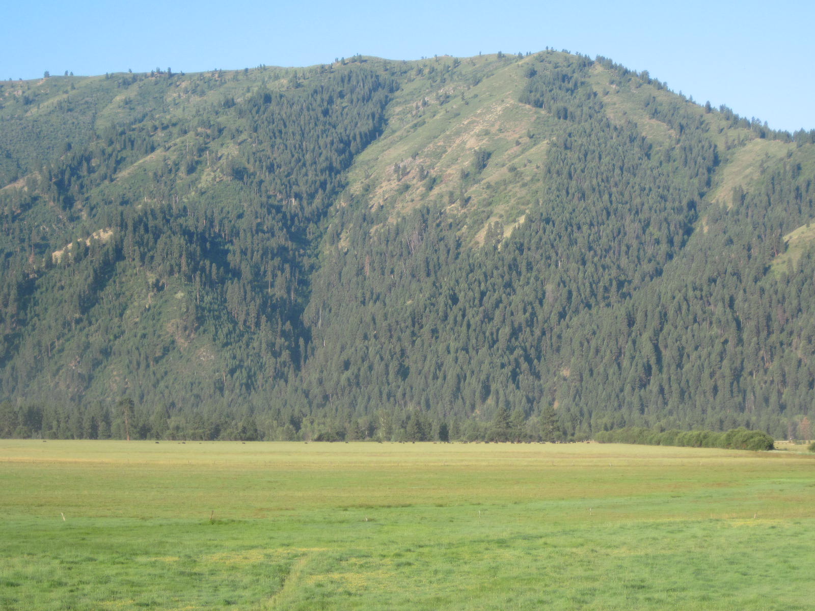  There didn't seem to be much in the town of Garden Valley, but they did have an airport.  Just past the airport, the road was joined by the South Fork of the Payette River. In this shot, it was still in the shade, giving it a silver-blue tinge.  The river had cut a pretty deep canyon through the hills and I had uphill views all around.  I wondered if a fire had denuded the distant hilltops in this photo.  The river views combined with a very low traffic highway made for magical biking.   I had been told by several people that the road to Lowman would be a hard climb. Yet, it seemed to have as much downhill and up. Here's one of the downs.  Here's one of the ups.  There were some vistas that I couldn't resist, even through I had taken several already.  Occasionally, I'd have to look hard to see the river views.  Though, for the most part, the river was hard to miss.  When I saw the river rafts, I wondered if it was more fun to be riding a bike upstream or bumping along in a raft downstream.  In addition to the Payette River, I passed several creeks that flowed into it. Here is Deadwood Creek.  There was even a roadside waterfall.  I arrived at Lowman, where the road ended, about 10:30am. The route, while it was definitely uphill and required some low gear grinding, was not as hard as I'd been lead to believe. My guess is that it is a hard road to drive as the road is narrow, curvy, and has lots of speed restrictions. On a bike, none of that counts for much. The town of Lowman, like many I'd seen in Idaho, was a set of spread out buildings. Lowman was unusual because it had a number of lodges. Here is the information sign on Lowman.  Lowman was the first milestone on this ride and I was still feeling quite fresh. But, I needed a break and some food. I stopped at the South Fork Lodge to rest, check email, and eat another breakfast. I took down a nice cheese, bell pepper, onion and jalapeno omelet with hash browns and toast. I sat in the shade and felt great. As I was leaving, it occurred to me that people often ask about what a bike tourist does with his bike when he goes into a store so I thought I'd take a picture of what I did with my bike. Granted, the South Fork Lodge was not very busy on this day, but I simply left my bike unlocked behind the ice machine, mostly hidden from view. Here is what you could see from the parking lot in front of the lodge. 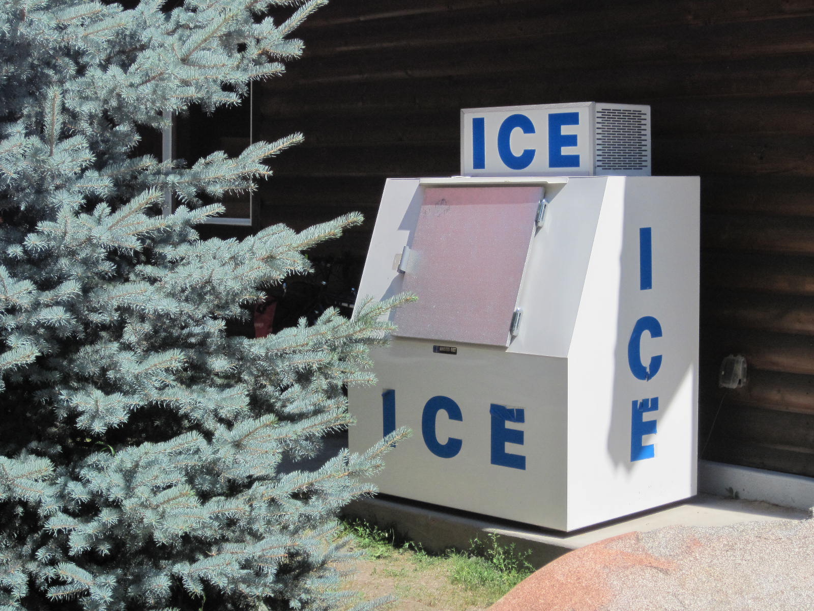 The only problem was that I hadn't noticed that I'd left right under one of the air-conditioners and my panniers were wet from dripping water! Lowman is one of the few towns between Boise and Stanley. The Banks-Lowman road dumps into Highway 21.  I turned left and headed off toward Stanley. I had left the Wildlife Scenic Byway and was now on the Ponderosa Pine Scenic Byway.  And, it was scenic.   Not far from Lowman is a Forest Service office and a large campground right on the river. I didn't stop, as I'd just started again and I didn't need any information. The traffic was a bit heaver here but it was mainly concentrated around the campground. In addition to the Payette River, there were lots of feeder streams. I heard this one and it took a while to locate it.  The road went up and down, always beside the river. The views ranged from fire damaged hillsides  to arid countryside,  to forest vistas.  Larger mountains always seemed to loom in the distance.  I started noticing large, white, puffy clouds in the sky. It was quite hot and I wondered if I was in for some rain later on.  I stopped 12 miles past Lowman at the Sourdough restaurant and motel. I think it had a gas station, as well. I wasn't all that hungry, but I wanted to get out of the sun, enjoy some air conditioning, get water and ice, and rest a bit. There wouldn't be any other services until Stanley, 45 miles away. The restaurant didn't serve vegiburgers so I had a chocolate malt, instead. It was very good! While sitting there cooling off, I asked if they could make me an avocado sandwich for the road and the chef said "Of course." I was there for maybe 30 minutes and left with a camelback full of ice and water. The road continued up and down always keeping the river in sight.  Just after the (dirt) turnoff to Grandjean, I stopped at a roadside rest area to eat some of the avocado sandwich and grab some shade. The view of the Sawtooth Mountains was stunning.  I took lots of photos, including this full zoomed shot.  As I was eating my sandwich, a VW van pulled in and I got to talking with the driver. He and his partner were doing some camping and it was a nice break to talk for a while. I asked him how far he thought Banner Pass was and he got out a road atlas and we decided it was 10 miles up the road. He asked if I needed some water and filled up my waterbag from bottles he was carrying. It was very nice of him to offer water and it is one of many appreciative interactions I've had with car drivers over the years. As it turned out, the 10 mile estimate was very close to reality. The road started up from that rest stop and kept the same incline for the next 10 miles up to Banner Pass. Here is the view of the incline a short ways past the rest stop.  For the next 10 miles, I was grinding away in my second lowest gear maintaining a speed of about 4.5 MPH. As I climbed, the views became broader.  The river still ran next to the road but it was getting smaller and smaller.  The road often ran through narrow valleys with tree-lined sides.  The lightly traveled road was in fairly good repair and had a reasonable shoulder.  While we had estimated 10 miles to the pass from the rest stop, I kept hoping that the pass would be around the next bend.  From where this picture was taken, I had another hour and a half of uphill grind. Suddenly, wildflowers appeared next to the river. I hadn't seen any this whole trip so I was presently surprised by them.  They were around all the way up to the pass and got more intense as I climbed higher. These two are my favorites.   I hit Banner Summit (7200 feet) at about 6:30pm. If anyone is interested, the summit occurred between roadside mile marker 105 and 106.  But, in the time it took me to take three pictures at the summit sign, I was bit many times by mosquitoes. Even though I was tired, the idea of spending the night being swarmed by bloodsuckers was not appealing. The ride down from the Pass was not particularly steep and often required me to pedal to maintain speed.  There were lots of pit toilet equipped camping areas that sat in broad meadows.  On the other side of the pass, there was still lots of flowing water visible from the road.  In addition to the meadows, there were distant mountains in every vista.  But, every time I stopped for one of these photos, I was swarmed by mosquitoes and bitten several times. This further lessened my desire to sleep showerless in my tent. Eventually, I remembered the bug spray I had bought in Oregon, rustled through my panniers, sprayed myself and was finally left alone. It was getting late and I needed to decide where I would be for the night. If I was going to ride to Stanley, about 20 miles past the Pass, I would have to make some good time to arrive before dark. The reasons for riding on was a desire for a shower and bed and the fact that I had determined that I needed to do an 80 mile day to complete the trip on time. The reasons against were that I was tired and that camping in this area had been recommended. I decided to push on to Stanley. Much of the time riding to Stanley would be looking at long, tree-lined meadows.  While there was likely some downhill slant to the road, it didn't seem to effect the effort needed to ride. Also, time was getting short and I needed to cover a lot of ground in a reasonable time. I rode as hard as I could given the miles I had done. Luckily, there wasn't much uphill. Eventually, the Sawtooths came into view.  What I struck me about this pretty vista is the tiny little shed in the distance.  I took lots of photos of the looming mountains. Some were close-ups.  While others were a bit broader. 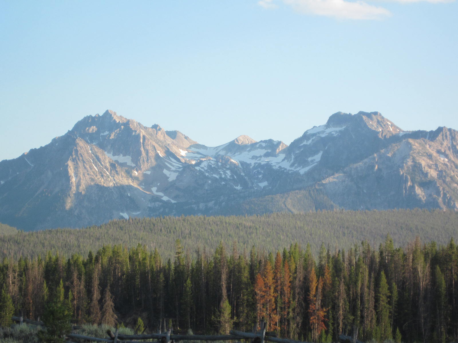 But these pictures don't do justice to the incredible views on this road. This shot of Stanley was taken at 8:30pm. The sun was going down, I was tired, and I wanted a place to eat, shower and sleep.  The first motel I passed was full. I kept riding. The next one was full, as well. Then, I was in the center of Stanley, a town of only 100 full-time residents, and found that all motels were booked for the night. This was a major letdown. Since I had camping gear, I had a place to sleep, but the question became where to pitch the tent (and why had I done all that extra mileage just to sleep on the ground, anyway)? I made some phone calls and discovered that all the motels in Lower Stanley, a community about 1 mile from (Upper?) Stanley right along the Salmon River. The last guy I spoke with, after hearing my sad story, suggested the Forest Service campground about a mile past Lower Stanley. I dejectedly got back on my bike, rode through Stanley and then Lower Stanley, and found the pull off to the campground in so little light that I had to ride without wearing my sunglasses. This "campground" was nothing more than an empty lot; no toilets, no water. I got off my bike, put up my tent and was too tired to cook anything. Instead, I raided my panniers for dry food and had a dinner of M&Ms, peanuts, and raisins. After I was settled in, I wondered about bears, knowing that it is a very bad idea to keep food in your tent with bears around. I hadn't seen any "Beware the Bear" signs all day and none in the campground proper but I wanted to be sure. There was another tent in the campground and I yelled over and asked him about bears but he had just arrived that day, as well. In the end, I decided to keep the panniers near the tent to prevent smaller critters from getting into them and not to worry about bears. I stretched out in my sleeping bag tired, dejected, and disappointed. I didn't sleep well, either, as every sound made me want to shine a flashlight out into the night. |
||||
|
|
||||