|
|
||||
| Date | Starting Place | Ending Place | Author | Last Update |
|
|
||||
| 09-14-06 |
Kirkwood, California, United States |
Carson City, Nevada, United States |
ray | 03-15-09 00:51:02 |
|
|
||||
|
When laying all night on a stone floor, it is hard to say when the night ended and the day began. For sure, things changed at 6:30am when someone came out of the lobby to start their day. I was off the floor and holding the door in one smooth motion. At first, all I did was sit on the couch, thinking how nice it would have been to have lain there all night. I knew that the closest place to eat breakfast (1 mile away) opened at 8am, so I was in no hurry to get up and out. I was tired. I went to the bathroom, washed up as best I could and started to get ready for the day's ride, which would take me over Carson Pass and all the way to Carson City. The reception staff started arriving about 7:30. Each one gave me an odd look as they walked through the lobby but said nothing. I decided not to say anything as there was nothing they could do and I doubt any of these people had enough authority to do anything meaningful anyway. I finally was able to drag myself up and out about 8am. The road out of Kirkwood is in very poor repair and I was swerving all over trying not to hit potholes. At the intersection of Kirkwood road and Highway 88, I took these pictures. As you can see, it was a bit cloudy. What you can't see is that it also was a bit windy. But, in the best news I'd had in a long while, the wind was at my back. This picture is looking toward the west up toward Carson Spur (elevation 7990), which at the top of the Silver Lake grade.  This view is toward the east and Carson Pass, about 500 vertical feet from here (and a bit off to the right).  Just to complete the panorama, this is a view back toward the Kirkwood ski resort.  The Kirkwood Inn is just around the bend from the intersection and I quickly drank down 2 mugs of coffee to wake up. I ate a very nice omelet and once the coffee kicked in was ready for the run up to the pass. Just over a hump from the Kirkwood Inn is Caples lake.  The road goes around the lake on two sides and provides lots of vistas. Here are two of the nicest.   Once past Caples Lake, you go around a bend and up an incline (next to a passing lane with virtually no shoulder) and you are at Carson Pass, elevation 8574, It wasn't a particularly hard climb to the pass as I had a strong tailwind. I asked someone to take this picture, which is not a very good one, but has meaning to me!  I knew the descent down the other side would be a bit treacherous as the wind through the pass was strong and swirling. This is what the road down from the pass look like.  Just down from the pass is a vista point of Red Lake. I stopped here to let my brakes cool.  Here is view going down. Incidentally, there was very little room to the right of the white line on this road. But, that early in the morning the traffic was light and I was going downhill with a tail wind.  The road angles down fairly steeply for about 4 miles, mostly around Red Lake. Highway 88 then flattens out as it goes through Hope Valley, which was cut by the Carson River. 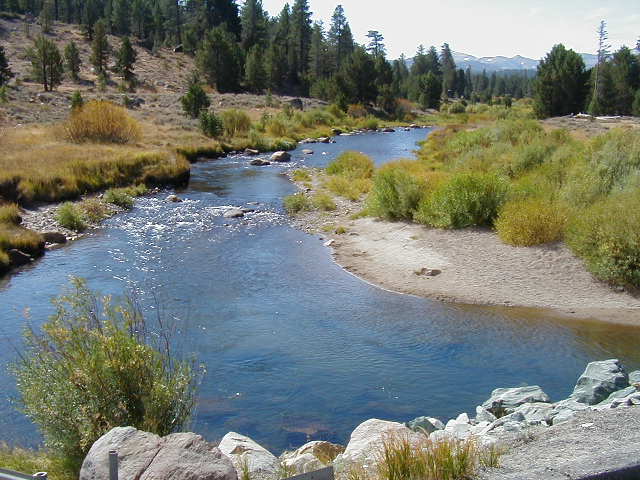 Between the wind and the down slope, I didn't have to peddle too hard, which was fine by me. The views were fabulous. Here is a typical valley vista.  Highway 89, the road to Lake Tahoe, joins the route near the east end of Hope Valley and just west of Sorenson's resort, a place to stay and eat that offers a hot tub and sauna. I didn't stop as I wasn't hungry and I was going to spend the night. I would stop there on the way back, I figured.  From that junction, the route heads more steeply downhill.  After 6 downhill miles, following the west fork of the Carson River, I came to Woodfords, where Highway 89 separates from the route and turns back west for Markleville and points south. To give you a sense of the drop, in 15 miles the elevation goes from 8574 at the pass to about 5600 at Woodfords. There are a few buildings in Woodfords, one housing a store/deli counter. The woman being the counter was one of the least pleasant waitresses I've ever met. She was curt, insulting, and inattentive. She even gave me a dirty look when I asked for another glass of water! That said, she made a great sandwich. The route drops steadily from Woodfords to the California border. The terrain became high desert.  This is a view south not far from Woodfords.  If anything, the tailwind was even stronger the further down I went. On this stretch of road, I was tooling along when I looked down as noticed I was going 48 MPH! With a tailwind, that kind of speed sounds like 25 MPH!  Once into Nevada, the route goes along big, empty cattle ranches set up against the Carson Mountains, which separate this valley from Lake Tahoe.  The same river that meanders through the Hope Valley, ran along this route, too.  The first settlement in Nevada is on the way to Carson City. It is called Genoa, pronounced Gen-Oh-A. It is a quaint town with the oldest saloon in Nevada and several shops. I stopped at a bakery and had a grilled cheese sandwich for meal number 3 of the day.  The weather was looking nasty and it even started to rain a bit when I was leaving Genoa. It was still quite blustery but now the wind was beginning to swirl. It would be behind me, then in front of me, and then coming form the side, all in 5 minutes. This picture will give you some view of looming weather. 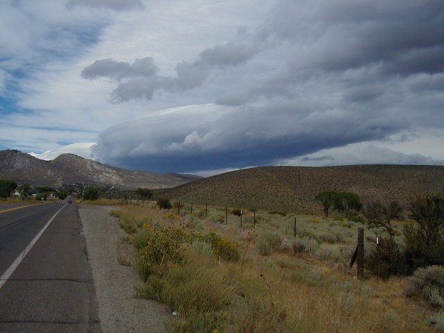 The ride from Genoa to Carson City 10 mile road through Jacks Valley on wide shouldered road.  The route dumps you onto 395. Carson City is sprawling down 395 and for miles there is every kind of fast food, big box store, and car dealership you can imagine. Once Highway 50 joins 395, the bike path ends and it gets scary with fast cars zooming a foot away from you. I had read that this section of 395 was dangerous and I had taken a map of Carson City with me so I could find some quieter roads. In fact, down just one street, there is a bicycle 395 that offers a bike lane and slow traffic. I rode into the older part of town (circa 1950) and eventually found a hotel on the main drag, Carson Street. As luck would have it, this was the weekend of the Reno Airshow and the hotel rates were much higher than normal. This night, my room cost $40. The next night, it cost $100! |
||||
|
|
||||